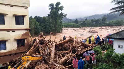
ISRO's atlas, based on extensive satellite data and geospatial analysis, ranks Kerala's Idukki, Wayanad, and Malappuram districts as particularly vulnerable. This assessment is grounded in factors like topography, soil type, rainfall patterns, and historical landslide incidents. The atlas is part of a broader initiative by ISRO to use space technology for disaster risk reduction and management.
The vulnerability of Kerala to landslides is not new. The state's hilly terrain and heavy monsoon rains create a perfect storm for such natural disasters. In 2018, Kerala experienced devastating floods and landslides, causing significant loss of life and property. The ISRO atlas aims to provide actionable insights to mitigate such risks in the future.
The atlas identifies more than 20,000 landslide-prone locations across India, with the Western Ghats, a mountain range running parallel to the western coast of the Indian peninsula, being a critical hotspot. Kerala, nestled within these ghats, faces a compounded risk due to deforestation, unregulated construction, and agricultural practices that destabilize the soil.
Experts emphasize that the data from ISRO’s landslide atlas should be integrated into regional planning and disaster management strategies. Kiran Kumar, former ISRO chairman, stated that leveraging space technology can significantly enhance our understanding of natural hazards and improve preparedness. He highlighted the importance of collaboration between scientific communities, policymakers, and local administrations to translate this data into effective ground-level actions.
Local authorities in Kerala have already begun to respond to the atlas's findings. The Kerala State Disaster Management Authority (KSDMA) has initiated awareness campaigns and training programs aimed at educating residents about landslide risks and safety measures. Efforts are also being made to incorporate landslide risk assessments into building regulations and land-use planning to prevent construction in high-risk areas.
Environmentalists in Kerala stress the need for sustainable development practices to address the root causes of landslides. Vandana Shiva, an environmental activist, pointed out that unchecked deforestation and quarrying activities have significantly weakened the region's ecological balance. She advocates for stringent regulations on land use and construction activities to preserve the natural landscape and reduce landslide occurrences.
The ISRO atlas also serves as a critical tool for emergency response teams. By pinpointing vulnerable areas, it allows for quicker, more targeted evacuation and relief efforts during landslide events. This precision can save lives and reduce the economic impact of such disasters.
While the ISRO atlas provides a comprehensive overview of landslide risks, it is a dynamic tool that will be regularly updated with new data and insights. This ongoing refinement ensures that disaster preparedness strategies remain current and effective in the face of changing environmental conditions and human activities.
The emphasis on advanced technological solutions, such as satellite data, for disaster risk management reflects a broader trend in leveraging space-based technologies for sustainable development. As India continues to face the challenges posed by natural disasters, initiatives like the ISRO landslide atlas underscore the crucial role of science and technology in safeguarding communities and building resilience.
With Kerala's inclusion in the top 50 landslide-prone regions, the state stands at a critical juncture. The effective use of ISRO's data can not only prevent tragedies but also foster a culture of proactive disaster management.
